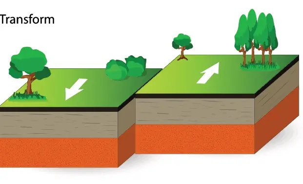
A transform boundary (also called a transform fault), is a fractured area or Faultline on the earth’s surface where two tectonic plates slide horizontally past each other.
The plates’ grinding action against each other can produce phenomenal effects such as shallow earthquakes, widespread deformation of the crust, and displacement of rock.
Transform plate boundaries typically form on seafloors where they act as connections between mid-ocean spreading ridges. However, they can also form on land.
The movements of the plates as they slide past each other are not smooth. This is because of the interlocking that takes place between the two sides. Such locks can hold tectonic forces that accumulate over time.
Eventually, the intensifying force overcomes the lock, causing a slip and a huge jump, usually extending to 8 meters. This is the cause of massive earthquakes.
Transform boundaries are also termed strike-slip boundaries, transform fault boundaries, conservative plate boundaries, or transform plate margins.
Transform boundaries don’t always exist alone. In fact, the huge Pacific Plate features all boundary types i.e., convergent, divergent, and transform boundaries.
One key aspect of transform plate that distinguishes it from divergent boundaries and convergent boundaries is that crust is not created or destroyed.
This is unlike divergent boundaries where new oceanic crust is generated and convergent boundaries where old oceanic crust undergoes destruction.
Here are 7 transform boundary examples.
1. San Andreas Fault
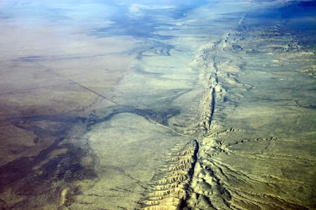
If you are a resident of California, you may be very accustomed to frequent predictions about imminent earthquakes—some of which pass.
The cause of all this sensation is the San Andreas Fault which is the best-known transform boundary.
It lies in western North America. The fault links the Cascadia subduction zone with a divergent boundary running through the Gulf of California.
The fault is responsible for some deadly major earthquakes such as the San Francisco earthquake of 1906 and the Loma Prieto earthquake of 1989.
Although San Francisco is currently located 340 km north of Los Angeles, their positions will be reversed given 16 million years!
That’s because one city is located in one plate and the other in the other plate that are moving relative to each other.
2. Alpine Fault
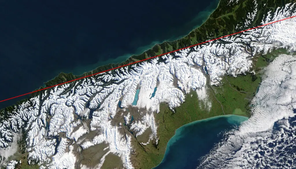
This fault is located in New Zealand. It is characterized by the horizontal sliding motion between the Australian plate in the Pacific plate.
This lateral movement has created the Southern Alps. These are mountain ranges with an interesting feature: they rise by 7 millimeters each year.
However, they also undergo a similar rate of erosion leaving their level relatively unchanged.
The alpine fault runs 600 km through the South Island and is clearly visible on land when viewed from space.
At 30 m per 1000 years, its movement is considered to be quite fast.
Geologists believe that in the past almost 900 years, rupturing of the fault has occurred four times
3. Chaman Fault
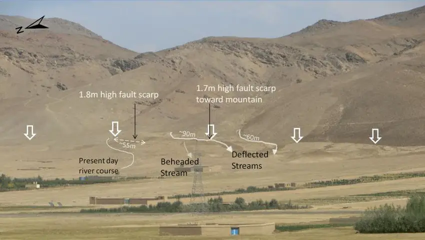
This 850 km fault is located in Afghanistan and Pakistan.
It consists of numerous connected faults that mark the boundary of the Indo-Australian plate and the Eurasian plate.
It is Afghanistan’s largest fault, running through Chaman, a town in southern Afghanistan.
You can enjoy a view of its full length which can be seen from the air and space.
4. North Anatolian Fault
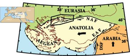
Almost equaling the size of the San Andreas fault, this fault separates the Anatolian Plate and the Eurasian plate.
It’s located in Turkey, making it a very earthquake-prone area.
One of its striking features is that it runs quite close to Istanbul at about just 20km.
This poses a hazard to the densely populated Turkish city. It has produced some deadly earthquakes.
You may also want to check: 10 Examples of Ores
5. Dead Sea Transform fault
The Dead Sea is known for its famous therapeutic waters, ultra-low levels, and historical settings for some biblical documented events.
But it is known also for much more, such as its transform fault that marks the borderline of the Arabian Plate and the African plate.
This fault with its system of branching faults ranks as one of the most significant earthquake areas of the Middle East.
Its southern part has generated some depression features such as the sea of Galilee, Gulf of Aqaba, Hula basins, and the Dead Sea itself.
6. Queen Charlotte Fault
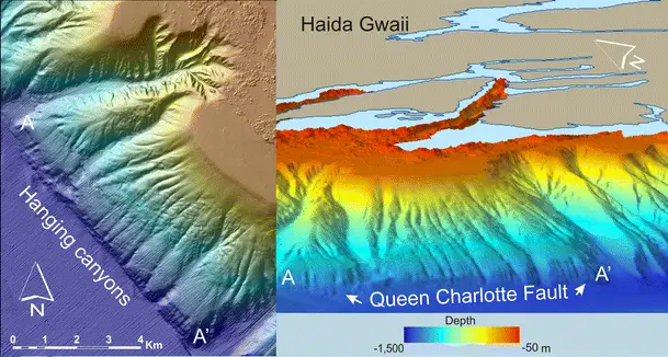
This fault extends for more than 900 km marking the boundary of the North American plates and the Pacific Plates.
It has been the scene of powerful earthquakes, five of which occurred in only the last 100 years, the latest being the 2013 magnitude 7.5 one.
7. Sagaing Fault
This 1200 km fault lies between the Sunda Plate and the Indian plate.
It runs right through the Asian nation Myanmar, with several urban areas on its path such as Pyi Taw which is Myanmar’s capital.
Its average movement per year is about 16 to 20 millimeters.
The lock it produces tends to remain for several years before releasing the accumulated stress in huge earthquakes.
More than 10 earthquakes have been associated with it in the 20th century with the latest being in 1956 when a 7.1 magnitude earthquake struck near Mandalay killing 38 people.
TRENDING:7 Intrusive Igneous Rocks Examples
Conclusion
The transform boundaries truly live up to their name as transforming beasts.
They remold or revamp the earth’s surface leaving a trail of geologic features.
With amazing forces still locked up in interlocked plates only to be released in thousands of years to come, we can only speculate what new fascinating features are still in the works!
Related Posts:
Image sources: 1, 2, 3